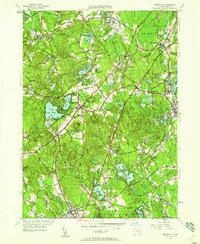
1945 Map of Wrentham
USGS Topo · Published 1958About this map
The town of Wrentham sits at the heart of this mid-century survey, surrounded by a complex network of glacial ponds and wetlands that define the local drainage. To the north, the State Prison Colony and Pondville Hospital appear as significant institutional footprints, while the New York New Haven and Hartford RR provides the primary industrial artery connecting Foxboro and Norfolk. Large water bodies like Lake Pearl and Lake Archer highlight the area's transition into a residential and recreational landscape, evidenced by the Franklin Country Club and numerous summer-named features.
Find a feature on this map
84 named features on this map. Tap any name to fly to it.
Don’t see what you’re looking for? This feature index may not catch every label — zoom into the map to look around manually.
Map Details
Editions of this 1945 Wrentham Map
This is the sole edition of this map. No revisions or reprints were ever made.
Other maps of this area

1885 · Taunton
USGS Topo · 1:62,500

1886 · Dedham
USGS Topo · 1:62,500

1887 · Franklin
USGS Topo · 1:62,500

1887 · Providence
USGS Topo · 1:62,500

1888 · Taunton
USGS Topo · 1:62,500

1889 · Providence
USGS Topo · 1:62,500

1889 · Franklin
USGS Topo · 1:62,500

1893 · Taunton
USGS Topo · 1:62,500

1893 · Franklin
USGS Topo · 1:62,500

1894 · Dedham
USGS Topo · 1:62,500