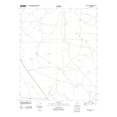
2010 Map of Wright Ranch
USGS Topo · Published 2010About this map
Water management defines this arid landscape of De Baca County, where a complex network of tanks, lakes, and draws supported the ranching economy of the early 21st century. The map centers on the Wright Ranch, a primary hub connected by rural routes such as County Rd-1-42 and County Rd-1-51. Notable landmarks like the High Lonesome Windmill and Six Windmills signify the vital infrastructure required to harness groundwater across this expanse of eastern New Mexico.
Find a feature on this map
35 named features on this map. Tap any name to fly to it.
Don’t see what you’re looking for? This feature index may not catch every label — zoom into the map to look around manually.
Map Details
Editions of this 2010 Wright Ranch Map
This is the sole edition of this map. No revisions or reprints were ever made.
Other maps of this area

1954 · Fort Sumner
USGS Topo · 1:250,000

1958 · Fort Sumner
USGS Topo · 1:250,000

1966 · El Morro Mesa
USGS Topo · 1:24,000

1967 · Wire Lake
USGS Topo · 1:24,000

1967 · Devils Well
USGS Topo · 1:24,000

1967 · Ramon
USGS Topo · 1:24,000

1967 · Ramon SW
USGS Topo · 1:24,000
1967 · The Old Dry Lake
USGS Topo · 1:24,000

1967 · Wright Ranch
USGS Topo · 1:24,000

1979 · Fort Sumner
USGS Topo · 1:100,000