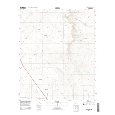
2013 Map of Wright Ranch
USGS Topo · Published 2013About this map
Arid ranchlands and livestock infrastructure dominate this De Baca County landscape, centered on the Wright Ranch and the vital water sources required for desert survival. The terrain is carved by ephemeral drainage systems like Ragland Draw, Turner Draw, and Indian Draw, which direct occasional flow toward the Pecos River valley to the west. Evidence of the area's grazing heritage is found in the extensive network of tanks and windmills, including the uniquely named High Lonesome Windmill, Panama Martin Tank, and Six Windmills. A glimpse into the logistical history of the region is preserved in labels such as Mail Carrier Lake and Dipping Vat Lake, likely markers of historic transit and cattle-handling practices. Transportation is defined by the corridor of Us-285, which cuts through the southwestern corner near Coyote Tank, providing the primary link between the remote rangelands and regional hubs.
Find a feature on this map
45 named features on this map. Tap any name to fly to it.
Don’t see what you’re looking for? This feature index may not catch every label — zoom into the map to look around manually.
Map Details
Editions of this 2013 Wright Ranch Map
This is the sole edition of this map. No revisions or reprints were ever made.
Other maps of this area

1954 · Fort Sumner
USGS Topo · 1:250,000

1958 · Fort Sumner
USGS Topo · 1:250,000

1966 · El Morro Mesa
USGS Topo · 1:24,000

1967 · Wire Lake
USGS Topo · 1:24,000

1967 · Devils Well
USGS Topo · 1:24,000

1967 · Ramon
USGS Topo · 1:24,000

1967 · Ramon SW
USGS Topo · 1:24,000
1967 · The Old Dry Lake
USGS Topo · 1:24,000

1967 · Wright Ranch
USGS Topo · 1:24,000

1979 · Fort Sumner
USGS Topo · 1:100,000