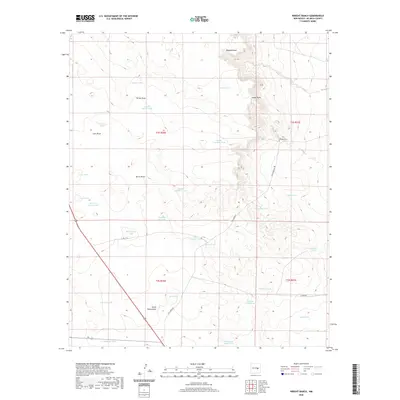
2020 Map of Wright Ranch
USGS Topo · Published 2020About this map
Wright Ranch sits at the center of this cattle country landscape, where the topography is defined by a sophisticated network of water management features essential for ranching in De Baca County. The terrain is carved by numerous drainage patterns such as Ragland Draw, Loco Draw, and Burro Draw, which feed into specialized reservoirs. These artificial and natural catchments, including Dipping Vat Lake, Mail Carrier Lake, and Red Lake, illustrate the historic reliance on seasonal water for livestock. The prevalence of named tanks like Panama Martin Tank, Dunlap Camp Tank, and Robertson Fence Tank suggests a landscape divided into specific grazing allotments and managed family holdings. Infrastructure is sparse, primarily consisting of unpaved ranch roads such as Yeso Creek Rd and Ramen Rd, which connect these remote outposts to the wider region.
Find a feature on this map
37 named features on this map. Tap any name to fly to it.
Don’t see what you’re looking for? This feature index may not catch every label — zoom into the map to look around manually.
Map Details
Editions of this 2020 Wright Ranch Map
This is the sole edition of this map. No revisions or reprints were ever made.
Other maps of this area

1954 · Fort Sumner
USGS Topo · 1:250,000

1958 · Fort Sumner
USGS Topo · 1:250,000

1966 · El Morro Mesa
USGS Topo · 1:24,000

1967 · Wire Lake
USGS Topo · 1:24,000

1967 · Devils Well
USGS Topo · 1:24,000

1967 · Ramon
USGS Topo · 1:24,000

1967 · Ramon SW
USGS Topo · 1:24,000
1967 · The Old Dry Lake
USGS Topo · 1:24,000

1967 · Wright Ranch
USGS Topo · 1:24,000

1979 · Fort Sumner
USGS Topo · 1:100,000