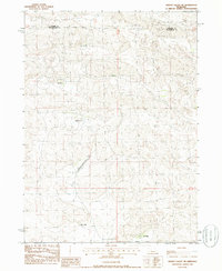
1985 Map of Wright Valley NE
USGS Topo · Published 1986About this map
The boundary between Hooker Co and McPherson Co divides this section of the Nebraska Sandhills, a landscape defined by its isolated cattle ranching heritage in the mid-1980s. The map illustrates a network of family-operated operations, including the R Connell Ranch, H Connell Ranch, and the Moore Ranch, all situated among the characteristic undulations of the terrain. The infrastructure of these remote holdings is notably represented by the Pioneer Ranch Landing Strip, which serves the Pioneer Ranch in the central portion of the sheet. Other local landmarks like the Calhoun Ranch and Haase Ranch further anchor the settlement pattern, showing how these operations were spaced across the hills. This document captures the region just as modern aerial photography was being used to update decades of traditional surveying, providing a clear record of the area's ranching footprint.
Find a feature on this map
8 named features on this map. Tap any name to fly to it.
Don’t see what you’re looking for? This feature index may not catch every label — zoom into the map to look around manually.
Map Details
Editions of this 1985 Wright Valley NE Map
This is the sole edition of this map. No revisions or reprints were ever made.
Other maps of this area

1947 · Dismal River Ranch
USGS Topo · 1:62,500

1949 · Dismal River Ranch
USGS Topo · 1:62,500

1949 · Wright Valley
USGS Topo · 1:62,500

1950 · Shimmins Lake
USGS Topo · 1:62,500

1951 · Tryon
USGS Topo · 1:62,500

1951 · Wright Valley
USGS Topo · 1:62,500

1954 · North Platte
USGS Topo · 1:250,000

1956 · North Platte
USGS Topo · 1:250,000

1957 · North Platte
USGS Topo · 1:250,000

1967 · North Platte
USGS Topo · 1:250,000