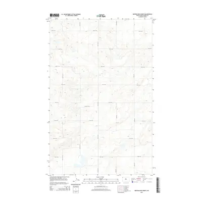
2014 Map of Writing Rock North
USGS Topo · Published 2014About this map
Glacial depressions and prairie potholes define this section of Divide County, where a strictly orthogonal road grid imposes order on a fluid, wetland-heavy landscape. The terrain is characterized by numerous small, unnamed water bodies and seasonal basins that interrupt the agricultural sections typical of North Dakota's northwest corner. Movement through the area is dictated by a network of gravel and section-line roads, including CR-7 and 146th Ave NW. These routes, such as 100th St NW and 93rd St NW, trace the section boundaries of a sparsely populated region where the environment remains the primary architect of the land's utility. The high density of topographic contours near the basin edges illustrates the localized elevation changes that create this distinctive pothole geography.
Find a feature on this map
14 named features on this map. Tap any name to fly to it.
Don’t see what you’re looking for? This feature index may not catch every label — zoom into the map to look around manually.
Map Details
Editions of this 2014 Writing Rock North Map
This is the sole edition of this map. No revisions or reprints were ever made.
Other maps of this area

1948 · Stady
USGS Topo · 1:24,000

1953 · Williston
USGS Topo · 1:250,000

1957 · Williston
USGS Topo · 1:250,000

1983 · Colgan West
USGS Topo · 1:24,000

1983 · Writing Rock North
USGS Topo · 1:24,000

1983 · Alkabo
USGS Topo · 1:24,000

1983 · Alexandria
USGS Topo · 1:24,000

1983 · Writing Rock South
USGS Topo · 1:24,000
1983 · Fortuna
USGS Topo · 1:24,000
1983 · Skjermo Lake
USGS Topo · 1:24,000