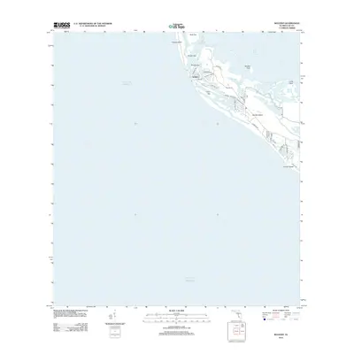
2012 Map of Wulfert
USGS Topo · Published 2012About this map
Wulfert sits at the nexus of several shifting coastal waterways, anchoring a landscape defined by the intricate separation of barrier islands. This 2012 survey reveals the detailed residential and natural layout of northern Sanibel Island and the southern tip of Captiva Island, divided by the narrow inlet of Blind Pass. The map highlights the complex hydrologic network of Pine Island Sound and the Gulf of Mexico, including sheltered waters like Halloway Bayou and Kesson Bayou. Inland, a dense network of local roads such as Wulfert Rd and Sanibel Captiva Rd indicates the area's development. Notable landmarks like Buck Key, Silver Key, and Sanibel Rocks provide critical reference points for understanding the topographical character of Lee County's southwestern coast during the early 21st century.
Find a feature on this map
39 named features on this map. Tap any name to fly to it.
Don’t see what you’re looking for? This feature index may not catch every label — zoom into the map to look around manually.
Map Details
Editions of this 2012 Wulfert Map
This is the sole edition of this map. No revisions or reprints were ever made.
Other maps of this area

1956 · Tampa
USGS Topo · 1:250,000

1956 · Charlotte Harbor
USGS Topo · 1:250,000

1958 · Captiva
USGS Topo · 1:24,000

1958 · Sanibel
USGS Topo · 1:24,000

1958 · Pine Island Center
USGS Topo · 1:24,000
1958 · Wulfert
USGS Topo · 1:24,000

1959 · Tampa
USGS Topo · 1:250,000

1960 · Tampa
USGS Topo · 1:250,000

1972 · Tampa
USGS Topo · 1:250,000
1981 · Sanibel
USGS Topo · 1:100,000