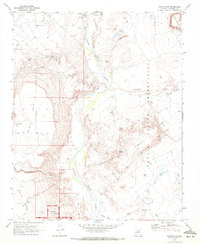
1969 Map of Wupatki NE
USGS Topo · Published 1972About this map
The Little Colorado River carves a central path through this landscape, separating the volcanic formations of Black Point and White Mesa from the expanse of the Navajo Indian Reservation. This 1969 survey documents a sparsely populated but historically significant corridor, featuring the northern boundaries of Wupatki National Monument where several Ruins are preserved. The terrain is defined by dramatic elevations like Baah Kokaa Ridge and the prominent cliffs of Ward Terrace. Evidence of land use is found in scattered mines and water management features such as Yellow Spring, Ely Tank, and a Corral. Seasonal drainages including Tohachi Wash and Jackrabbit Wash trace the complex topography of the high desert plateau, while a network of Jeep Trails provides the primary access through the reservation land east of the river.
Find a feature on this map
25 named features on this map. Tap any name to fly to it.
Don’t see what you’re looking for? This feature index may not catch every label — zoom into the map to look around manually.
Map Details
Editions of this 1969 Wupatki NE Map
2 editions found
Other maps of this area

1886 · San Francisco Mtns
USGS Topo · 1:250,000

1891 · San Francisco Mtns
USGS Topo · 1:250,000

1894 · San Francisco Mtns
USGS Topo · 1:250,000

1899 · San Francisco Mtns
USGS Topo · 1:250,000

1947 · Flagstaff
USGS Topo · 1:250,000

1954 · Flagstaff
USGS Topo · 1:250,000

1955 · Black Falls 4 SW
USGS Topo · 1:24,000

1955 · Black Falls NE
USGS Topo · 1:24,000

1955 · Cameron SW
USGS Topo · 1:24,000
1955 · Cameron SE
USGS Topo · 1:24,000