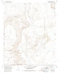
1969 Map of Wupatki NE
USGS Topo · Published 1986About this map
The Little Colorado River defines the heart of this Coconino County landscape, carving a path through high desert terrain at the end of the 1960s. To the west, the volcanic shelf of Black Point and the rising elevations of White Mesa overlook the river valley, while the eastern banks lie within the Navajo Indian Reservation. This area is notable for its concentration of ancient sites, specifically at the northern edge of Wupatki National Monument, where the Crack in Rock Ruins indicate a long history of human occupation.
Find a feature on this map
2 named features on this map. Tap any name to fly to it.
Don’t see what you’re looking for? This feature index may not catch every label — zoom into the map to look around manually.
Map Details
Editions of this 1969 Wupatki NE Map
2 editions found
Other maps of this area

1886 · San Francisco Mtns
USGS Topo · 1:250,000

1891 · San Francisco Mtns
USGS Topo · 1:250,000

1894 · San Francisco Mtns
USGS Topo · 1:250,000

1899 · San Francisco Mtns
USGS Topo · 1:250,000

1947 · Flagstaff
USGS Topo · 1:250,000

1954 · Flagstaff
USGS Topo · 1:250,000

1955 · Black Falls 4 SW
USGS Topo · 1:24,000

1955 · Black Falls NE
USGS Topo · 1:24,000

1955 · Cameron SW
USGS Topo · 1:24,000
1955 · Cameron SE
USGS Topo · 1:24,000