
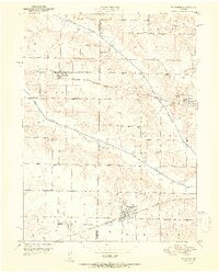
1951 Map of Wyaconda
USGS Topo · Published 1951About this map
Wyaconda sits at the intersection of early 1950s rail and road commerce, where the Santa Fe railroad and the Atchison Topeka and Santa Fe lines cross the northeast Missouri landscape. This area is defined by the winding paths of the South Wyaconda River and the Little Wyaconda River, which carve through the townships of Thomson, Washington, and Harrison. The map provides a clear look at the rural infrastructure of Clark and Scotland counties, documenting the placement of numerous family and community landmarks like Etna Cem and Combs Cem.
Find a feature on this map
31 named features on this map. Tap any name to fly to it.
Don’t see what you’re looking for? This feature index may not catch every label — zoom into the map to look around manually.
Map Details
Editions of this 1951 Wyaconda Map
2 editions found
Other maps of this area

1903 · Kahoka
USGS Topo · 1:125,000

1903 · Edina
USGS Topo · 1:125,000

1950 · Neeper
USGS Topo · 1:24,000

1950 · Medill
USGS Topo · 1:24,000

1950 · Colony
USGS Topo · 1:24,000

1951 · Colony
USGS Topo · 1:24,000

1951 · Neeper
USGS Topo · 1:24,000

1951 · Medill
USGS Topo · 1:24,000

1954 · Centerville
USGS Topo · 1:250,000

1957 · Centerville
USGS Topo · 1:250,000