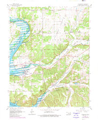
1961 Map of Wyandotte
USGS Topo · Published 1982About this map
Lake of the Cherokees and the Lake o' the Cherokees (Neosho River) dominate this 1960s landscape, illustrating the water-management priorities of the mid-20th century in northeastern Oklahoma. The map reveals a complex overlay of historic tribal territories, including the Ottawa Indian Reservation Boundary, Shawnee Indian Reservation Boundary, and Modoc Indian Reservation, marking the enduring heritage of the region. The settlement of Wyandotte serves as a central hub, where the Burlington Northern railroad infrastructure cuts through the Modoc Valley. Local industry is represented by the Tripoli Mines and several Gravel Pits, while the rural social fabric is evidenced by numerous schools like Story Point Sch and local landmarks such as Sycamore Chapel. The terrain transitions from the open spaces of Jackson Prairie to the carved valleys of Lost Creek and Sycamore Creek.
Find a feature on this map
38 named features on this map. Tap any name to fly to it.
Don’t see what you’re looking for? This feature index may not catch every label — zoom into the map to look around manually.
Map Details
Editions of this 1961 Wyandotte Map
2 editions found

Other maps of this area

1907 · Wyandotte
USGS Topo · 1:125,000

1909 · Wyandotte
USGS Topo · 1:125,000

1949 · Seneca
USGS Topo · 1:24,000

1949 · Racine
USGS Topo · 1:24,000

1950 · Seneca
USGS Topo · 1:24,000

1950 · Racine
USGS Topo · 1:24,000

1954 · Tulsa
USGS Topo · 1:250,000

1958 · Tulsa
USGS Topo · 1:250,000
1960 · Peoria
USGS Topo · 1:24,000

1961 · Miami SE
USGS Topo · 1:24,000