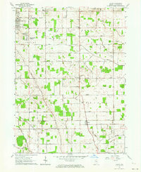
1961 Map of Wyatt
USGS Topo · Published 1964About this map
Wyatt and Woodland serve as the primary hubs in this part of St. Joseph County, anchoring a landscape defined by small-town life and precise agricultural drainage. The area north of Centre shows the mid-century suburban expansion of South Bend through several residential tracts like Crest Manor Addition and Hi-View Addition. In contrast, the southern townships of Madison and Union remain deeply rural, characterized by a dense network of drainage canals such as Wyatt Ditch and Bunch Ditch (East Branch) that transformed the wet prairie into productive farmland.
Find a feature on this map
64 named features on this map. Tap any name to fly to it.
Don’t see what you’re looking for? This feature index may not catch every label — zoom into the map to look around manually.
Map Details
Editions of this 1961 Wyatt Map
2 editions found
Other maps of this area

1953 · Chicago
USGS Topo · 1:250,000

1957 · Chicago
USGS Topo · 1:250,000

1958 · South Bend East
USGS Topo · 1:24,000

1958 · South Bend West
USGS Topo · 1:24,000

1958 · Bremen
USGS Topo · 1:24,000

1958 · La Paz
USGS Topo · 1:24,000

1958 · Nappanee West
USGS Topo · 1:24,000

1958 · Osceola
USGS Topo · 1:24,000

1958 · Lakeville
USGS Topo · 1:24,000
1961 · Wakarusa
USGS Topo · 1:24,000