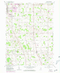
1961 Map of Wyatt
USGS Topo · Published 1981About this map
South Bend expansion and the rural agricultural character of St. Joseph County define this landscape as it appeared in the early 1960s. Residential growth is evident in the northern portion of the quadrangle through named subdivisions like Gilmer Park, Crest Manor Addition, and Miami Trails Addition, while several large radio towers, including those for Wsbt-TV and Wndu-TV, mark the skyline.
Find a feature on this map
32 named features on this map. Tap any name to fly to it.
Don’t see what you’re looking for? This feature index may not catch every label — zoom into the map to look around manually.
Map Details
Editions of this 1961 Wyatt Map
2 editions found
Other maps of this area

1953 · Chicago
USGS Topo · 1:250,000

1957 · Chicago
USGS Topo · 1:250,000

1958 · South Bend East
USGS Topo · 1:24,000

1958 · South Bend West
USGS Topo · 1:24,000

1958 · Bremen
USGS Topo · 1:24,000

1958 · La Paz
USGS Topo · 1:24,000

1958 · Nappanee West
USGS Topo · 1:24,000

1958 · Osceola
USGS Topo · 1:24,000

1958 · Lakeville
USGS Topo · 1:24,000
1961 · Wakarusa
USGS Topo · 1:24,000