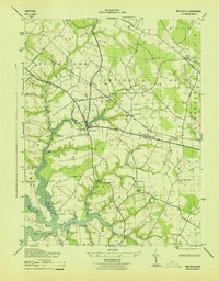
1943 Map of Wye Mills
USGS Topo · Published 1943About this map
Wye Mills serves as the focal point of this Maryland interior, where the Baltimore And Eastern rail line and established thoroughfares like Bloomingdale Road intersect. The landscape is deeply defined by the branching waters of the Wye River, Mill Creek, and Skipton Creek, which carve into the terrain to create the prominent Neck and Wye Island. These waterways served as vital arteries for the agricultural districts of Queenstown No 5 and Centerville No 3, connecting inland farms to the Wye East River.
Find a feature on this map
28 named features on this map. Tap any name to fly to it.
Don’t see what you’re looking for? This feature index may not catch every label — zoom into the map to look around manually.
Map Details
Editions of this 1943 Wye Mills Map
This is the sole edition of this map. No revisions or reprints were ever made.
Other maps of this area

1898 · Choptank
USGS Topo · 1:125,000

1898 · Tolchester
USGS Topo · 1:125,000

1899 · Dover
USGS Topo · 1:125,000

1901 · Chestertown
USGS Topo · 1:62,500

1903 · Tolchester
USGS Topo · 1:125,000

1904 · St. Michaels
USGS Topo · 1:62,500

1905 · Denton
USGS Topo · 1:62,500

1905 · Barclay
USGS Topo · 1:62,500

1906 · Dover
USGS Topo · 1:125,000

1908 · Tolchester
USGS Topo · 1:125,000