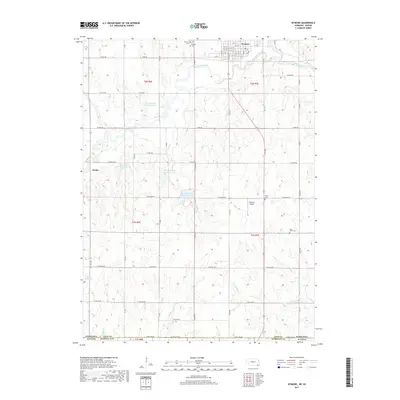
2017 Map of Wymore
USGS Topo · Published 2017About this map
The Big Blue River and Big Indian Creek define the hydrologic character of this Southeast Nebraska landscape, where the town of Wymore serves as the primary hub near the northern boundary. This 2017 survey reveals a highly organized agricultural grid, punctuated by a series of water management projects including Big Indian Cr Reservoir 2-A, Big Indian Cr Reservoir 2-B, and Big Indian Creek Reservoir 11-A. For genealogists, the map is particularly useful for locating rural burial sites such as Bethel Cem, Saint Johns Cem, and the twin cemeteries of Wymore Cem and Calvary Cem north of the main settlement. Small-scale infrastructure like the Thomsen Airport and the crossroads at Krider illustrate the persistence of rural communities along the State Line Rd bordering Kansas, while numerous small waterways like Otoe Cr and Meadow Cr thread through the township sections of Gage and Marshall counties.
Find a feature on this map
41 named features on this map. Tap any name to fly to it.
Don’t see what you’re looking for? This feature index may not catch every label — zoom into the map to look around manually.
Map Details
Editions of this 2017 Wymore Map
This is the sole edition of this map. No revisions or reprints were ever made.
Other maps of this area

1889 · Marysville
USGS Topo · 1:125,000

1894 · Marysville
USGS Topo · 1:125,000

1955 · Manhattan
USGS Topo · 1:250,000

1955 · Lincoln
USGS Topo · 1:250,000

1956 · Manhattan
USGS Topo · 1:250,000

1957 · Manhattan
USGS Topo · 1:250,000

1957 · Lincoln
USGS Topo · 1:250,000

1958 · Lincoln
USGS Topo · 1:250,000

1964 · Blue Springs
USGS Topo · 1:24,000

1966 · Oketo
USGS Topo · 1:24,000