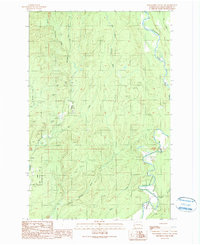
1990 Map of Wynoochee Valley NW
USGS Topo · Published 1990About this map
The Wynoochee River winds through the eastern portion of this quadrangle, forming deep meanders and oxbows within its valley. This 1990 provisional map documents a region defined by commercial and conservation land use, including the extensive Olympic State Wildlife Area. The western half of the map is dominated by the intricate drainage systems of the Wishkah River, including its East Fork and West Fork. Human activity is concentrated along these waterways, with the presence of a Fish Hatchery and several resource extraction sites like a Borrow Pit and Quarry. The terrain is characterized by numerous small tributaries such as Big River, Carter Creek, and Helm Creek feeding into the primary river systems. A lone Footbridge provides a rare crossing point, emphasizing the character of this timber and wildlife management landscape.
Find a feature on this map
16 named features on this map. Tap any name to fly to it.
Don’t see what you’re looking for? This feature index may not catch every label — zoom into the map to look around manually.
Map Details
Editions of this 1990 Wynoochee Valley NW Map
This is the sole edition of this map. No revisions or reprints were ever made.
Other maps of this area

1921 · Quinault Lake
USGS Topo · 1:62,500

1921 · Satsop
USGS Topo · 1:62,500

1941 · Mobray
USGS Topo · 1:62,500

1943 · Humptulips
USGS Topo · 1:62,500

1943 · Mobray
USGS Topo · 1:62,500

1955 · Wynoochee Valley
USGS Topo · 1:62,500

1955 · Grisdale
USGS Topo · 1:62,500

1955 · Humptulips
USGS Topo · 1:62,500

1955 · Quinault Lake
USGS Topo · 1:62,500

1958 · Seattle
USGS Topo · 1:250,000