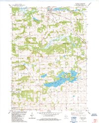
1984 Map of Wyocena
USGS Topo · Published 1984About this map
Wyocena stands as the central settlement in this 1980s topographical record, situated along the crossroads of the Milwaukee St Paul and Pacific rail line. The landscape is defined by its complex glacial hydrology, where Duck Creek and its Middle Branch wind through a series of kettle lakes and wetlands. Prominent among these are Wyocena Lake, Curtis Lake, and the expansive Mud Lake State Public Hunting Grounds, which occupies much of the central Lowville township. Beyond the village, the map records rural markers like the Rocky Run Cem, Lowville Cem, and several local schools including Wyocena School and Lowville School. The terrain is also dotted with specialized agricultural and industrial sites such as the Poynette State Game Farm and numerous gravel pits, reflecting the area's mid-century economic character.
Find a feature on this map
1 named feature on this map. Tap any name to fly to it.
Don’t see what you’re looking for? This feature index may not catch every label — zoom into the map to look around manually.
Map Details
Editions of this 1984 Wyocena Map
This is the sole edition of this map. No revisions or reprints were ever made.
Other maps of this area

1901 · Poynette
USGS Topo · 1:62,500

1902 · Portage
USGS Topo · 1:62,500

1955 · Randolph
USGS Topo · 1:62,500

1955 · Columbus
USGS Topo · 1:62,500

1957 · Madison
USGS Topo · 1:250,000

1960 · Madison
USGS Topo · 1:250,000

1962 · Poynette
USGS Topo · 1:62,500

1962 · Portage
USGS Topo · 1:62,500
1980 · North Bristol
USGS Topo · 1:24,000
1980 · Rio
USGS Topo · 1:24,000