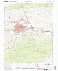
1968 Map of Wytheville
USGS Topo · Published 1991About this map
Wytheville serves as the focal point of this late-1960s survey, showing its development at the intersection of major transportation routes. The urban core is detailed with civic and social landmarks including the Courthouse, Spiller Sch, and the Wytheville Sanitarium and Hospital. To the west, Pine Ridge and the Wytheville Golf Club mark the transition toward more rural terrain, while the Norfolk and Western railway lines cut through the valley, highlighting the town's industrial and logistical importance.
Find a feature on this map
62 named features on this map. Tap any name to fly to it.
Don’t see what you’re looking for? This feature index may not catch every label — zoom into the map to look around manually.
Map Details
Editions of this 1968 Wytheville Map
4 editions found
Other maps of this area

1887 · Pocahontas
USGS Topo · 1:125,000

1889 · Hillsville
USGS Topo · 1:125,000

1889 · Wytheville
USGS Topo · 1:125,000

1890 · Dublin
USGS Topo · 1:125,000

1891 · Pocahontas
USGS Topo · 1:125,000

1891 · Dublin
USGS Topo · 1:125,000

1892 · Hillsville
USGS Topo · 1:125,000

1892 · Wytheville
USGS Topo · 1:125,000

1894 · Pocahontas
USGS Topo · 1:125,000

1895 · Pocahontas
USGS Topo · 1:125,000