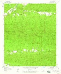
1958 Map of Y City
USGS Topo · Published 1959About this map
Y City serves as the focal point for this 1958 survey, situated where the Fourche La Fave River meets the northern foothills of the Ouachita National Forest. The landscape is dominated by the steep ridges of Mill Creek Mountain and Irons Fork Mountain, with the latter divided by the deep cut of Posey Hollow. This era of the Ozark-Ouachita region reveals a landscape in transition, where the Eureka Sch (Abandoned) stands as a reminder of shifting rural populations, even as the Wolf Pinnacle Lookout Tower maintains its vigil over the timberlands from its high vantage point at Wolf Pinnacle. Local family and place names are preserved through landmarks like Goldsberry Mountain and Chant Cem, while the drainage patterns of Mill Creek, Irons Fork, and Slaty Creek illustrate the watercourses that shaped early settlement and travel in the Scott and Polk county borderlands.
Find a feature on this map
37 named features on this map. Tap any name to fly to it.
Don’t see what you’re looking for? This feature index may not catch every label — zoom into the map to look around manually.
Map Details
Editions of this 1958 Y City Map
2 editions found
Other maps of this area

1879 · Poteau Mountain
USGS Topo · 1:62,500

1887 · Poteau Mountain #1
USGS Topo · 1:62,500

1887 · Mount Ida #2
USGS Topo · 1:62,500

1890 · Mount Ida
USGS Topo · 1:125,000

1890 · Poteau Mountain
USGS Topo · 1:125,000

1899 · Poteau Mountain
USGS Topo · 1:125,000

1939 · Waldron
USGS Topo · 1:62,500

1940 · Waldron
USGS Topo · 1:62,500

1941 · Waldron
USGS Topo · 1:62,500

1949 · Waldron
USGS Topo · 1:62,500