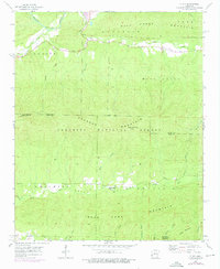
1958 Map of Y City
USGS Topo · Published 1976About this map
Y City sits at the northern edge of the Ouachita National Forest, a central point for the forestry and transport corridors of western Arkansas. The topography is defined by a series of prominent ridges, including Fourche Mountain and Mill Creek Mountain, which overlook the winding Fourche La Fave River and Mill Creek. This 1950s survey, updated with mid-1970s photogrammetric data, captures the rural institutional landscape of the era, noting the Eureka Sch (Abandoned) and the Chant Cem.
Find a feature on this map
36 named features on this map. Tap any name to fly to it.
Don’t see what you’re looking for? This feature index may not catch every label — zoom into the map to look around manually.
Map Details
Editions of this 1958 Y City Map
2 editions found
Other maps of this area

1879 · Poteau Mountain
USGS Topo · 1:62,500

1887 · Poteau Mountain #1
USGS Topo · 1:62,500

1887 · Mount Ida #2
USGS Topo · 1:62,500

1890 · Mount Ida
USGS Topo · 1:125,000

1890 · Poteau Mountain
USGS Topo · 1:125,000

1899 · Poteau Mountain
USGS Topo · 1:125,000

1939 · Waldron
USGS Topo · 1:62,500

1940 · Waldron
USGS Topo · 1:62,500

1941 · Waldron
USGS Topo · 1:62,500

1949 · Waldron
USGS Topo · 1:62,500