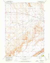
1951 Map of Y U Bench NW
USGS Topo · Published 1976About this map
Y U Bench dominates this high-plains landscape in Wyoming's Park County, revealing a complex network of water management features developed for early 20th-century agriculture. The topographic data highlights the defunct Wiley Canal (Aban'd) in the northwest, a relic of ambitious irrigation projects that shaped the Missouri River Basin. In the lower southeast corner, the Greybull R flows past the Keystone Burlington-Meeteetse Ditch and Jimmerfield Ditch, demonstrating how water was diverted from the river to the arid benchland. The terrain is defined by the branching drainage systems of the North Fork Dry Creek and South Fork Dry Creek within the wider Dry Creek Basin. Local transportation and landmarks are sparse but specific, including Lone Tree Crossing, a solitary Gravel Pit, and various survey markers like Beach.
Find a feature on this map
24 named features on this map. Tap any name to fly to it.
Don’t see what you’re looking for? This feature index may not catch every label — zoom into the map to look around manually.
Map Details
Editions of this 1951 Y U Bench NW Map
2 editions found
Other maps of this area

1911 · Oregon Basin
USGS Topo · 1:62,500

1913 · Oregon Basin
USGS Topo · 1:62,500

1951 · Y U Bench NW
USGS Topo · 1:24,000

1951 · Y U Bench NE
USGS Topo · 1:24,000

1951 · Tatman Mountain
USGS Topo · 1:24,000

1951 · Sheets Flat
USGS Topo · 1:24,000

1955 · Cody
USGS Topo · 1:250,000

1958 · Cody
USGS Topo · 1:250,000

1962 · Cody
USGS Topo · 1:250,000

1966 · Gilmore Hill SE
USGS Topo · 1:24,000