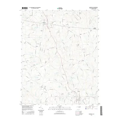
2016 Map of Yadkinville
USGS Topo · Published 2016About this map
Yadkinville serves as the regional hub at the southern edge of this landscape, where the foothills of the North Carolina Piedmont meet a dense network of tributaries. The terrain is defined by the winding paths of Deep Cr, S Deep Cr, and North Deep Creek, which historically dictated the placement of settlements like Boonville and Center. The map reveals a high concentration of community landmarks, particularly country cemeteries such as Harmony Grove Cem and Deep Creek Friends Cem, which highlight the deep-rooted family lineages of Yadkin County. Small private aviation sites like Welborn Farm Airport and Boonville Airport punctuate the rural landscape, suggesting a mix of traditional agriculture and mid-century modern utility. Numerous small lakes and ponds, including Twiman Candle Lake and Howard Lake, are scattered throughout the region, illustrating how the local drainage has been managed for local use and recreation.
Find a feature on this map
176 named features on this map. Tap any name to fly to it.
Don’t see what you’re looking for? This feature index may not catch every label — zoom into the map to look around manually.
Map Details
Editions of this 2016 Yadkinville Map
This is the sole edition of this map. No revisions or reprints were ever made.
Other maps of this area

1891 · Yadkinville
USGS Topo · 1:125,000

1893 · Yadkinville
USGS Topo · 1:125,000

1953 · Winston-Salem
USGS Topo · 1:250,000

1955 · Winston-Salem
USGS Topo · 1:250,000

1962 · Winston-Salem
USGS Topo · 1:250,000
1966 · Farmington
USGS Topo · 1:24,000
1966 · Lone Hickory
USGS Topo · 1:24,000

1966 · Yadkinville
USGS Topo · 1:24,000

1966 · East Bend
USGS Topo · 1:24,000
1970 · Siloam
USGS Topo · 1:24,000