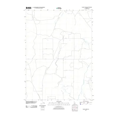
2010 Map of Yahoo Creek
USGS Topo · Published 2010About this map
Salmon Falls Creek winds through this agricultural and desert landscape of Twin Falls County, defining the drainage patterns of the western Snake River Plain. In the early 21st century, the area's irrigation and water management are visible through the Magic Water Canal and localized water sources like Coyote Spring and Rings Springs. The map illustrates a strict section-line road grid, including E 4900 N and N 600 E, which facilitates the region's ranching and farming operations. Highlighting a transition between developed fields and open range, the survey traces Yahoo Creek as it flows toward the north, while the Castleford Glenns Ferry Rd provides a primary transit link across the sagebrush-dotted terrain.
Find a feature on this map
20 named features on this map. Tap any name to fly to it.
Don’t see what you’re looking for? This feature index may not catch every label — zoom into the map to look around manually.
Map Details
Editions of this 2010 Yahoo Creek Map
This is the sole edition of this map. No revisions or reprints were ever made.
Other maps of this area

1949 · Pasadena Valley
USGS Topo · 1:62,500

1949 · Thousand Springs
USGS Topo · 1:24,000

1949 · Tuttle
USGS Topo · 1:24,000

1949 · Hagerman
USGS Topo · 1:24,000

1949 · Indian Butte
USGS Topo · 1:24,000

1950 · Hagerman
USGS Topo · 1:24,000
1950 · Indian Butte
USGS Topo · 1:24,000

1951 · Thousand Springs
USGS Topo · 1:24,000

1951 · Tuttle
USGS Topo · 1:24,000

1954 · Thousand Springs
USGS Topo · 1:24,000