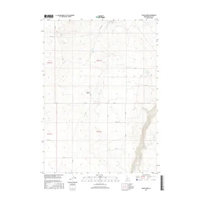
2017 Map of Yahoo Creek
USGS Topo · Published 2017About this map
Salmon Falls Creek carves a deep, winding canyon through the southeastern corner of this high plateau, defining a sharp contrast between the irrigated agricultural grid and the arid terrain of the Bruneau Desert. In this southern Idaho landscape, the development of water infrastructure is central, evidenced by the Magic Water Canal and the systematic layout of county roads such as 4700 N Rd and 500 E Rd. Named water sources like Coyote Spring and Rings Springs provide vital points of interest in an area where Yahoo Creek drains north through the sagebrush. This survey captures the intersection of early twentieth-century desert reclamation and the enduring topography of the Snake River Plain, showing how survey townships like t8s r13e were organized for cattle ranching and modern homesteading.
Find a feature on this map
28 named features on this map. Tap any name to fly to it.
Don’t see what you’re looking for? This feature index may not catch every label — zoom into the map to look around manually.
Map Details
Editions of this 2017 Yahoo Creek Map
This is the sole edition of this map. No revisions or reprints were ever made.
Other maps of this area

1949 · Pasadena Valley
USGS Topo · 1:62,500

1949 · Thousand Springs
USGS Topo · 1:24,000

1949 · Tuttle
USGS Topo · 1:24,000

1949 · Hagerman
USGS Topo · 1:24,000

1949 · Indian Butte
USGS Topo · 1:24,000

1950 · Hagerman
USGS Topo · 1:24,000
1950 · Indian Butte
USGS Topo · 1:24,000

1951 · Thousand Springs
USGS Topo · 1:24,000

1951 · Tuttle
USGS Topo · 1:24,000

1954 · Thousand Springs
USGS Topo · 1:24,000