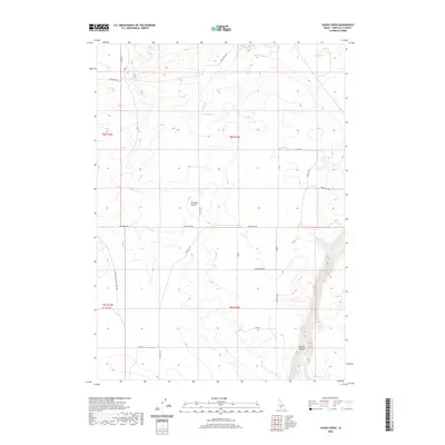
2020 Map of Yahoo Creek
USGS Topo · Published 2020About this map
Salmon Falls Creek carves a deep, winding path through the southeastern corner of this Idaho landscape, creating the dramatic topography of Sinking Canyon. This rugged canyon contrast sharply with the relatively level expanse of the Bruneau Desert that dominates the central portion of the map. Water management is a primary theme of the era, seen in the engineered path of the Magic Water Canal and the presence of scattered water sources like Coyote Spring and Rings Springs. The road network follows the grid system of the Public Land Survey, with routes such as 4700 North Rd and 500 East Rd dividing the desert into square sections. The Yahpo Cr drainage system flows through the northern reaches, while older arterial routes like Crows Nest Rd and the Castleford Glennis Ferry Rd provide connection across the sagebrush-covered plains of Twin Falls County.
Find a feature on this map
29 named features on this map. Tap any name to fly to it.
Don’t see what you’re looking for? This feature index may not catch every label — zoom into the map to look around manually.
Map Details
Editions of this 2020 Yahoo Creek Map
This is the sole edition of this map. No revisions or reprints were ever made.
Other maps of this area

1949 · Pasadena Valley
USGS Topo · 1:62,500

1949 · Thousand Springs
USGS Topo · 1:24,000

1949 · Tuttle
USGS Topo · 1:24,000

1949 · Hagerman
USGS Topo · 1:24,000

1949 · Indian Butte
USGS Topo · 1:24,000

1950 · Hagerman
USGS Topo · 1:24,000
1950 · Indian Butte
USGS Topo · 1:24,000

1951 · Thousand Springs
USGS Topo · 1:24,000

1951 · Tuttle
USGS Topo · 1:24,000

1954 · Thousand Springs
USGS Topo · 1:24,000