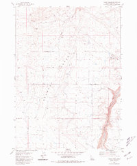
1980 Map of Yahoo Creek
USGS Topo · Published 1981About this map
The Bruneau Desert landscape of southern Idaho is defined here by the intersection of arid plateaus and vital water infrastructure as documented in the mid-1970s. The northern reaches are bisected by Yahoo Creek, which winds toward Coyote Spring, while the eastern margin is dominated by the dramatic topography of Sinking Canyon and Salmon Falls Creek. This area shows a high degree of land management, from the industrial presence of several Gravel Pits and a Borrow Pit to the complex irrigation network represented by the Magic Water Canal.
Find a feature on this map
23 named features on this map. Tap any name to fly to it.
Don’t see what you’re looking for? This feature index may not catch every label — zoom into the map to look around manually.
Map Details
Editions of this 1980 Yahoo Creek Map
This is the sole edition of this map. No revisions or reprints were ever made.
Other maps of this area

1949 · Pasadena Valley
USGS Topo · 1:62,500

1949 · Thousand Springs
USGS Topo · 1:24,000

1949 · Tuttle
USGS Topo · 1:24,000

1949 · Hagerman
USGS Topo · 1:24,000

1949 · Indian Butte
USGS Topo · 1:24,000

1950 · Hagerman
USGS Topo · 1:24,000
1950 · Indian Butte
USGS Topo · 1:24,000

1951 · Thousand Springs
USGS Topo · 1:24,000

1951 · Tuttle
USGS Topo · 1:24,000

1954 · Thousand Springs
USGS Topo · 1:24,000