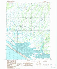
1987 Map of Yakutat B-4 NW
USGS Topo · Published 1988About this map
Yakutat Foreland is dominated by a complex network of glacial outwash and tidal influences in this late-twentieth-century survey. The landscape is defined by the braided path of the Ahrnklin River as it moves toward the Gulf of Alaska, depositing sediment that forms the substantial Blacksand Spit. This coastal boundary protects a series of dynamic waterways, including Middle Slough and the lower reaches of Seal Creek. Located within the Tongass National Forest, the area shows no roads or permanent structures, reflecting a wilderness state where the primary geographic changes occur through shifting Tidal Flats and the movement of Blacksand Island. The 1980s data provides a specific record of this shoreline's configuration before subsequent decades of coastal erosion and glacial siltation continued to reshape the river mouth.
Find a feature on this map
11 named features on this map. Tap any name to fly to it.
Don’t see what you’re looking for? This feature index may not catch every label — zoom into the map to look around manually.
Map Details
Editions of this 1987 Yakutat B-4 NW Map
This is the sole edition of this map. No revisions or reprints were ever made.
Other maps of this area

1951 · Yakutat
USGS Topo · 1:250,000

1959 · Yakutat B-5
USGS Topo · 1:63,360

1959 · Yakutat C-5
USGS Topo · 1:63,360

1959 · Yakutat C-4
USGS Topo · 1:63,360

1959 · Yakutat B-4
USGS Topo · 1:63,360

1959 · Yakutat
USGS Topo · 1:250,000

1987 · Yakutat C-4 SW
USGS Topo · 1:25,000
1987 · Yakutat C-4 SE
USGS Topo · 1:25,000
1987 · Yakutat C-5 SE
USGS Topo · 1:25,000
1987 · Yakutat B-5 NE
USGS Topo · 1:25,000