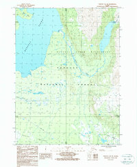
1987 Map of Yakutat C-4 SE
USGS Topo · Published 1988About this map
Russell Fiord dominates this coastal landscape, where glacial waters meet the heavily forested shores of the Tongass National Forest. The map documents a rugged interface of ice and timber, specifically tracing the Russell Fiord Wilderness Boundary through terrain shaped by the Fourth Glacier and drained by Beasley Creek. South of the fjord, the Yakutat Foreland represents a shift toward more accessible ground, marked by the presence of Gravel Pits and the trace of the Alsek Road. This 1987 provisional survey captures the region's wilderness character just as modern land designations were being codified, providing a precise look at topographic markers like Cape Stoss and the intricate tidal flats where the ice-melt enters the sea.
Find a feature on this map
14 named features on this map. Tap any name to fly to it.
Don’t see what you’re looking for? This feature index may not catch every label — zoom into the map to look around manually.
Map Details
Editions of this 1987 Yakutat C-4 SE Map
This is the sole edition of this map. No revisions or reprints were ever made.
Other maps of this area

1951 · Yakutat
USGS Topo · 1:250,000

1959 · Yakutat C-3
USGS Topo · 1:63,360

1959 · Yakutat C-4
USGS Topo · 1:63,360

1959 · Yakutat B-3
USGS Topo · 1:63,360

1959 · Yakutat B-4
USGS Topo · 1:63,360

1959 · Yakutat
USGS Topo · 1:250,000

1987 · Yakutat C-4 SW
USGS Topo · 1:25,000
1987 · Yakutat B-4 NW
USGS Topo · 1:25,000
1997 · Yakutat C-4
USGS Topo · 1:63,360
2017 · Yakutat B-4 NE
USGS Topo · 1:25,000