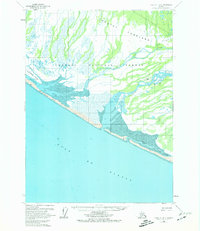
1959 Map of Yakutat B-4
USGS Topo · Published 1974About this map
The Yakutat Foreland meets the Gulf of Alaska in this mid-century portrait of coastal Alaska, where a network of glacial rivers and tidal flats define the geography. The expansive Tongass National Forest covers much of the inland area, giving way to dynamic water features like the Dangerous River and the Italio River. The mapping shows an early era of resource exploration and remote subsistence, marked by isolated cabins, an Oil Well, and a Drill Hole scattered across the lowlands. Near the coast, Blacksand Island and the long stretch of Blacksand Spit frame the complex estuary of the Ahrnklin River. These landmarks, along with a remote Landing Strip, reflect the vital importance of aviation and water transport in a landscape largely devoid of roads.
Find a feature on this map
19 named features on this map. Tap any name to fly to it.
Don’t see what you’re looking for? This feature index may not catch every label — zoom into the map to look around manually.
Map Details
Editions of this 1959 Yakutat B-4 Map
2 editions found
Other maps of this area

1951 · Yakutat
USGS Topo · 1:250,000

1959 · Yakutat C-3
USGS Topo · 1:63,360

1959 · Yakutat B-5
USGS Topo · 1:63,360

1959 · Yakutat C-5
USGS Topo · 1:63,360
1959 · Yakutat A-3
USGS Topo · 1:63,360

1959 · Yakutat C-4
USGS Topo · 1:63,360

1959 · Yakutat B-3
USGS Topo · 1:63,360

1959 · Yakutat B-4
USGS Topo · 1:63,360

1959 · Yakutat
USGS Topo · 1:250,000

1987 · Yakutat C-4 SW
USGS Topo · 1:25,000