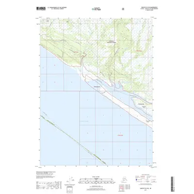
2017 Map of Yakutat B-5 NE
USGS Topo · Published 2017About this map
Lost River and the Situk River meander through the coastal lowlands of the Tongass National Forest before meeting the Gulf of Alaska. This portion of the Yakutat Borough is defined by a complex network of waterways, including Tawah Cr, Kunayosh Creek, and several sloughs that thread behind the barrier of Blacksand Island. A significant cultural landmark, the Chief Situk Grave, is located near the banks of the Situk River, highlighting the deep local history of the area. Access to this wilderness landscape is primarily provided by the Dry Bay Canoe Trail and Situk Landing Road, which connect the inland regions to the rugged coastline and the Yakutat Airport to the northwest.
Find a feature on this map
26 named features on this map. Tap any name to fly to it.
Don’t see what you’re looking for? This feature index may not catch every label — zoom into the map to look around manually.
Map Details
Editions of this 2017 Yakutat B-5 NE Map
This is the sole edition of this map. No revisions or reprints were ever made.
Other maps of this area

1951 · Yakutat
USGS Topo · 1:250,000

1959 · Yakutat B-5
USGS Topo · 1:63,360

1959 · Yakutat C-5
USGS Topo · 1:63,360

1959 · Yakutat C-4
USGS Topo · 1:63,360

1959 · Yakutat B-4
USGS Topo · 1:63,360

1959 · Yakutat
USGS Topo · 1:250,000

1987 · Yakutat C-4 SW
USGS Topo · 1:25,000
1987 · Yakutat C-5 SE
USGS Topo · 1:25,000
1987 · Yakutat B-5 NE
USGS Topo · 1:25,000
1987 · Yakutat C-5 SW
USGS Topo · 1:25,000