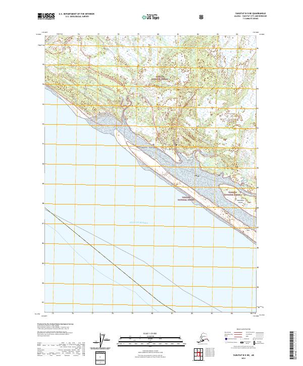
2021 Map of Yakutat B-5 NE
USGS Topo · Published 2021About this map
Chief Situk Grave stands as a significant cultural marker within the coastal landscape where the Situk River meets the Gulf of Alaska. This portion of the Tongass National Forest is defined by an intricate network of waterways, including Tawah Creek, Lost River, and Kunaqush Creek, which weave through the low-lying wetlands. The map illustrates a transition from the infrastructure of the Yakutat Airport in the north to the undeveloped shoreline features of Blacksand Island and Blacksand Spit. Local transportation is limited to specialized routes such as Situk Landing Road, Beach Road, and the Tawah Creek Trl, reflecting the area's reliance on river access and coastal navigation. The settlement at Situk remains a focal point in this tide-influenced environment, where the shifting sands of Black Sand North meet the open ocean.
Find a feature on this map
24 named features on this map. Tap any name to fly to it.
Don’t see what you’re looking for? This feature index may not catch every label — zoom into the map to look around manually.
Map Details
Editions of this 2021 Yakutat B-5 NE Map
This is the sole edition of this map. No revisions or reprints were ever made.
Other maps of this area

1951 · Yakutat
USGS Topo · 1:250,000

1959 · Yakutat B-5
USGS Topo · 1:63,360

1959 · Yakutat C-5
USGS Topo · 1:63,360

1959 · Yakutat C-4
USGS Topo · 1:63,360

1959 · Yakutat B-4
USGS Topo · 1:63,360

1959 · Yakutat
USGS Topo · 1:250,000

1987 · Yakutat C-4 SW
USGS Topo · 1:25,000
1987 · Yakutat C-5 SE
USGS Topo · 1:25,000
1987 · Yakutat B-5 NE
USGS Topo · 1:25,000
1987 · Yakutat C-5 SW
USGS Topo · 1:25,000