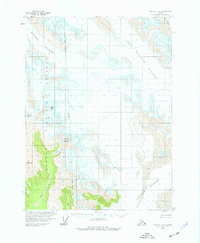
1959 Map of Yakutat C-3
USGS Topo · Published 1977About this map
Hidden Glacier and the massive Yakutat Glacier dominate this mid-century topographic study of the coastal mountain wilderness. This landscape is defined by the slow movement of ice and the erosion of sharp peaks like Slate Peak and the curiously named Black Tit. Within the Tongass National Forest, the map records an intricate network of drainage, where meltwater from the Moser Glacier feeds into Moser Creek and the Miller Glacier gives rise to Miller Creek. The presence of the National Forest Boundary (Indefinite) through the glacial valleys of West Nunatak Glacier reflects the difficulty of surveying this remote terrain during the era of aerial photogrammetry. Geologists and naturalists can observe the precise 1959 contours of Crescent Mountain and the Fourth Glacier before subsequent decades of glacial retreat altered the topography.
Find a feature on this map
15 named features on this map. Tap any name to fly to it.
Don’t see what you’re looking for? This feature index may not catch every label — zoom into the map to look around manually.
Map Details
Editions of this 1959 Yakutat C-3 Map
2 editions found
Other maps of this area

1951 · Yakutat
USGS Topo · 1:250,000

1959 · Yakutat C-3
USGS Topo · 1:63,360

1959 · Yakutat D-3
USGS Topo · 1:63,360

1959 · Yakutat D-4
USGS Topo · 1:63,360

1959 · Yakutat C-4
USGS Topo · 1:63,360

1959 · Yakutat B-3
USGS Topo · 1:63,360

1959 · Yakutat B-2
USGS Topo · 1:63,360

1959 · Yakutat B-4
USGS Topo · 1:63,360

1959 · Yakutat
USGS Topo · 1:250,000

1985 · Yakutat C-2
USGS Topo · 1:63,360