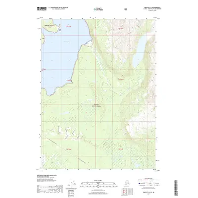
2017 Map of Yakutat C-4 SE
USGS Topo · Published 2017About this map
Tongass National Forest dominates this coastal landscape where the waters of Russell Fiord meet the rugged shoreline at Cape Stoss. In 2017, the area remained largely defined by its intricate drainage systems, characterized by unique local names like Match Stick, Mickey, and Lower 3-Fish. This survey documents a critical intersection of marine and freshwater environments, where Seal Creek and E Seal Creek flow through the lowlands south of the primary forest tracts. Human activity is evidenced primarily by the Yak. Road to Dangerous River, which provides a singular land-based route through the southern portion of the quadrangle. The map serves as a detailed record of the shifting watercourses and wetlands north of the Gulf of Alaska, showing the drainage of Beasley Cr and the complex network of the 3-Fish Creek system.
Find a feature on this map
18 named features on this map. Tap any name to fly to it.
Don’t see what you’re looking for? This feature index may not catch every label — zoom into the map to look around manually.
Map Details
Editions of this 2017 Yakutat C-4 SE Map
This is the sole edition of this map. No revisions or reprints were ever made.
Other maps of this area

1951 · Yakutat
USGS Topo · 1:250,000

1959 · Yakutat C-3
USGS Topo · 1:63,360

1959 · Yakutat C-4
USGS Topo · 1:63,360

1959 · Yakutat B-3
USGS Topo · 1:63,360

1959 · Yakutat B-4
USGS Topo · 1:63,360

1959 · Yakutat
USGS Topo · 1:250,000

1987 · Yakutat C-4 SW
USGS Topo · 1:25,000
1987 · Yakutat C-4 SE
USGS Topo · 1:25,000
1987 · Yakutat B-4 NW
USGS Topo · 1:25,000
1997 · Yakutat C-4
USGS Topo · 1:63,360