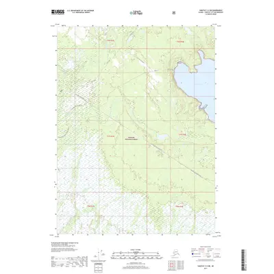
2017 Map of Yakutat C-4 SW
USGS Topo · Published 2017About this map
Tongass National Forest dominates this coastal landscape near Yakutat, where glacial waters and marshlands define the local geography. The complex hydrology of the region is centered on the Situk River, which flows through expansive wetlands alongside the Old Situk River. Access to the backcountry is marked by the Situk Lake Trail Head and the Yak. Road to Dangerous River, highlighting the area's importance for local transit and recreation. On the western shore of Russell Fiord, the map records specific points of human infrastructure such as E Gate and the Situk River (Middle Situk Cabin). Small drainages like Kunayah Creek and Seal Cr feed into the broader coastal basin, illustrating the fine-grained water network of the Alaskan panhandle.
Find a feature on this map
19 named features on this map. Tap any name to fly to it.
Don’t see what you’re looking for? This feature index may not catch every label — zoom into the map to look around manually.
Map Details
Editions of this 2017 Yakutat C-4 SW Map
This is the sole edition of this map. No revisions or reprints were ever made.
Other maps of this area

1951 · Yakutat
USGS Topo · 1:250,000

1959 · Yakutat B-5
USGS Topo · 1:63,360

1959 · Yakutat C-5
USGS Topo · 1:63,360

1959 · Yakutat C-4
USGS Topo · 1:63,360

1959 · Yakutat B-4
USGS Topo · 1:63,360

1959 · Yakutat
USGS Topo · 1:250,000

1987 · Yakutat C-4 SW
USGS Topo · 1:25,000
1987 · Yakutat C-4 SE
USGS Topo · 1:25,000
1987 · Yakutat C-5 SE
USGS Topo · 1:25,000
1987 · Yakutat B-5 NE
USGS Topo · 1:25,000