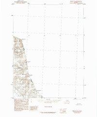
1985 Map of Yakutat D-2
USGS Topo · Published 1985About this map
Glacial ice dominates this high-altitude borderland between Alaska and British Columbia, where the Tongass National Forest meets the international boundary. Based on photography from 1958, the map illustrates the massive ice fields of the Saint Elias Mountains as they appeared during the mid-20th century. The ice flow of the East Nunatak Glacier and the Moraine Glacier carve through the landscape between prominent peaks such as Mount Armour and Mount Duff. This provisional edition serves as a record of the shifting glacial environment before modern satellite mapping, capturing the contours of the Mount Wade and Mount Herbert massifs along the Alaska and British Columbia border.
Find a feature on this map
10 named features on this map. Tap any name to fly to it.
Don’t see what you’re looking for? This feature index may not catch every label — zoom into the map to look around manually.
Map Details
Editions of this 1985 Yakutat D-2 Map
This is the sole edition of this map. No revisions or reprints were ever made.
Other maps of this area

1951 · Yakutat
USGS Topo · 1:250,000

1951 · Mt Saint Elias
USGS Topo · 1:250,000

1959 · Yakutat C-3
USGS Topo · 1:63,360

1959 · Yakutat D-3
USGS Topo · 1:63,360

1959 · Yakutat
USGS Topo · 1:250,000

1959 · Mt Saint Elias
USGS Topo · 1:250,000
1985 · Yakutat C-1
USGS Topo · 1:63,360
1985 · Mount Saint Elias A-3
USGS Topo · 1:63,360

1985 · Yakutat C-2
USGS Topo · 1:63,360
2017 · Yakutat C-1 NW
USGS Topo · 1:25,000