
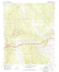
1981 Map of Yampai SE
USGS Topo · Published 1981About this map
The Juniper Mountains dominate this high-desert landscape in central Arizona, showing a region defined by arid-land water management and transportation corridors in the early 1980s. The map illustrates a reliance on specialized water infrastructure for ranching or resource use, featuring numerous named catchments such as Lindburg Tank, Pet Tank, and Forks in the Road Tank. These points of water access are scattered across the terrain near Black Mountain and Twin Buttes.
Find a feature on this map
18 named features on this map. Tap any name to fly to it.
Don’t see what you’re looking for? This feature index may not catch every label — zoom into the map to look around manually.
Map Details
Editions of this 1981 Yampai SE Map
2 editions found
Other maps of this area

1886 · Diamond Creek
USGS Topo · 1:250,000

1886 · Chino
USGS Topo · 1:250,000

1891 · Chino
USGS Topo · 1:250,000

1892 · Diamond Creek
USGS Topo · 1:250,000

1947 · Turkey Canyon
USGS Topo · 1:62,500

1948 · Williams
USGS Topo · 1:250,000

1950 · Turkey Canyon
USGS Topo · 1:62,500

1954 · Williams
USGS Topo · 1:250,000

1956 · Williams
USGS Topo · 1:250,000

1960 · Williams
USGS Topo · 1:250,000