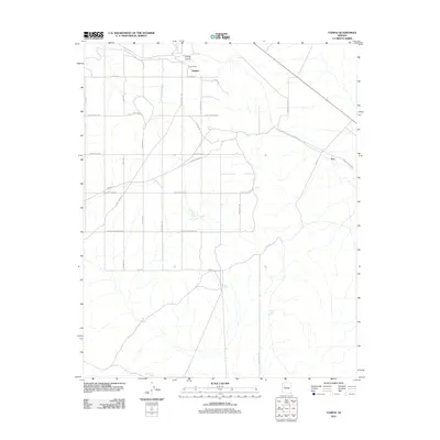
2011 Map of Yampai
USGS Topo · Published 2011About this map
Yampai and the high point at Yampai Divide anchor this high-desert landscape in Yavapai County, where the infrastructure of ranching and the railroad intersect. The map illustrates a grid of rural routes including Hyde Park Rd and Stewart Rd, which connect isolated outposts like Rock House and Pica. Water management is the defining characteristic of this arid region, evidenced by numerous named catchment features such as Sand Trap Tank, Windy Tank, and Camel Tank. These tanks, along with Section One Well, provided the essential resources for the cattle ranching operations that historically dominated the area. The presence of these named landmarks provides a specific window into the local ranching heritage and the challenge of sustaining agriculture on the plateau.
Find a feature on this map
29 named features on this map. Tap any name to fly to it.
Don’t see what you’re looking for? This feature index may not catch every label — zoom into the map to look around manually.
Map Details
Editions of this 2011 Yampai Map
This is the sole edition of this map. No revisions or reprints were ever made.
Other maps of this area

1886 · Diamond Creek
USGS Topo · 1:250,000

1892 · Diamond Creek
USGS Topo · 1:250,000

1948 · Williams
USGS Topo · 1:250,000

1954 · Williams
USGS Topo · 1:250,000

1956 · Williams
USGS Topo · 1:250,000

1960 · Williams
USGS Topo · 1:250,000

1961 · Williams
USGS Topo · 1:250,000
1967 · Nelson
USGS Topo · 1:24,000
1980 · Blye Canyon SE
USGS Topo · 1:24,000
1980 · Blye Canyon NE
USGS Topo · 1:24,000