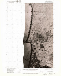
1975 Map of Yaquina NE
USGS Topo · Published 1979About this map
Newport and Agate Beach sit at the edge of the Pacific Ocean in this mid-1970s orthophoto survey of the central Oregon coastline. The aerial perspective reveals the dense forestation and winding coastal drainages that characterize the region just before the onset of modern expansion. Highway 101 serves as the primary artery, hugging the bluff lines and connecting the southern residential grids of Newport with the geologic curiosity of the Devils Punch Bowl to the north. This document provides a clear look at the land-use patterns of the era, contrasting the developed street systems in the south with the sprawling, undeveloped timberlands and coastal outcroppings that define the northern reaches of the quadrangle.
Find a feature on this map
5 named features on this map. Tap any name to fly to it.
Don’t see what you’re looking for? This feature index may not catch every label — zoom into the map to look around manually.
Map Details
Editions of this 1975 Yaquina NE Map
2 editions found
Other maps of this area

1941 · Cape Foulweather
USGS Topo · 1:62,500

1942 · Euchre Mtn
USGS Topo · 1:62,500

1942 · Yaquina
USGS Topo · 1:62,500

1942 · Toledo
USGS Topo · 1:62,500

1943 · Euchre Mtn
USGS Topo · 1:62,500

1944 · Cape Foulweather
USGS Topo · 1:62,500

1953 · Salem
USGS Topo · 1:250,000

1954 · Salem
USGS Topo · 1:250,000

1957 · Cape Foulweather
USGS Topo · 1:62,500

1957 · Yaquina
USGS Topo · 1:62,500