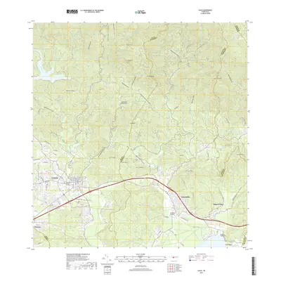
2018 Map of Yauco
USGS Topo · Published 2018About this map
Yauco and Guayanilla serve as the primary urban hubs in this southern Puerto Rican landscape, where the coastal plains meet the rising peaks of the Cordillera Central. The topography is defined by prominent elevations such as Pico Rodadero and Cerro Candiles, while a dense network of waterways including the Rio Yauco and Rio Guayanilla carve through the terrain. Local history is anchored by sites like the Viejo Cementerio Municipal de Yauco and the Cementerio Blanco. The map details the transition from the concentrated street grids of the towns, including Cll Comercio and Cll Betances, to smaller inland settlements like Las Cruces and Magas Arriba. Along the coast, Playa de Guayanilla and Punta Pepillo mark the maritime edge of the region, illustrating the long-standing connection between these mountain-shadowed communities and the Caribbean Sea.
Find a feature on this map
74 named features on this map. Tap any name to fly to it.
Don’t see what you’re looking for? This feature index may not catch every label — zoom into the map to look around manually.
Map Details
Editions of this 2018 Yauco Map
This is the sole edition of this map. No revisions or reprints were ever made.
Other maps of this area

1937 · Sabana Grande
USGS Topo · 1:25,000

1938 · Guanica
USGS Topo · 1:30,000

1941 · Sabana Grande
USGS Topo · 1:30,000

1946 · Maricao
USGS Topo · 1:30,000

1946 · Punta Cuchara
USGS Topo · 1:30,000

1946 · Yauco
USGS Topo · 1:30,000

1946 · Monte Guilarte
USGS Topo · 1:30,000

1946 · Punta Verraco
USGS Topo · 1:30,000

1946 · Penuelas
USGS Topo · 1:30,000

1946 · Adjuntas
USGS Topo · 1:30,000