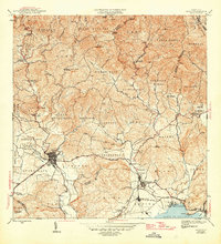
1946 Map of Yauco
USGS Topo · Published 1946About this map
Industrial and agricultural life in the mid-1940s centers on the American railroad and the Central Rufina sugar mill near the coast. The town of Yauco is clearly defined, divided into Pueblo Norte and Pueblo Sud, serving as a hub for the surrounding mountainous barrios. Moving north into the Cordillera Central, the landscape is dotted with coffee haciendas like Hacienda Pintado and Hacienda Mogote, reflecting the interior's historic plantation economy. The Río Yauco and Río Guayanilla wind through steep terrain, providing the essential water sources for these upland settlements and the coastal plains below. Education is represented by regional landmarks such as the Escuela Segunda Unidad de Duey, which served the rural workforce in the high sierra before the era of modern highway development.
Find a feature on this map
90 named features on this map. Tap any name to fly to it.
Don’t see what you’re looking for? This feature index may not catch every label — zoom into the map to look around manually.
Map Details
Editions of this 1946 Yauco Map
3 editions found
Other maps of this area

1937 · Sabana Grande
USGS Topo · 1:25,000

1938 · Guanica
USGS Topo · 1:30,000

1941 · Sabana Grande
USGS Topo · 1:30,000

1946 · Maricao
USGS Topo · 1:30,000

1946 · Punta Cuchara
USGS Topo · 1:30,000

1946 · Yauco
USGS Topo · 1:30,000

1946 · Monte Guilarte
USGS Topo · 1:30,000

1946 · Punta Verraco
USGS Topo · 1:30,000

1946 · Penuelas
USGS Topo · 1:30,000

1946 · Adjuntas
USGS Topo · 1:30,000