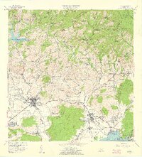
1958 Map of Yauco
USGS Topo · Published 1961About this map
Agricultural tradition and industrial emergence define this southwest coastal region during the late 1950s. The landscape is anchored by the urban center of Yauco, where the Parque Atlético Ovidio Rodríguez and the Cementerio Municipal serve the local community. The surrounding hills are dotted with a remarkable concentration of family estates, including Hacienda Pietri, Hacienda Roig, and Hacienda Catalina, reflecting the long-standing coffee and sugar economy of the barrios. Along the coast at the Bahía de Guayanilla, the transition toward modernization is evident with the Refinería de Petróleo and Termoeléctrica facilities near Central Rufina. This era shows the intricate water management system supporting both towns, featuring the Presa Antonio Lucchetti and a Respiradero de Túnel cutting through the northern cordillera.
Find a feature on this map
145 named features on this map. Tap any name to fly to it.
Don’t see what you’re looking for? This feature index may not catch every label — zoom into the map to look around manually.
Map Details
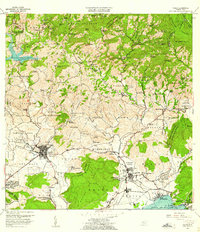
Editions of this 1958 Yauco Map
2 editions found
Other maps of this area

1937 · Sabana Grande
USGS Topo · 1:25,000

1938 · Guanica
USGS Topo · 1:30,000

1941 · Sabana Grande
USGS Topo · 1:30,000

1946 · Maricao
USGS Topo · 1:30,000

1946 · Punta Cuchara
USGS Topo · 1:30,000

1946 · Yauco
USGS Topo · 1:30,000

1946 · Monte Guilarte
USGS Topo · 1:30,000

1946 · Punta Verraco
USGS Topo · 1:30,000

1946 · Penuelas
USGS Topo · 1:30,000

1946 · Adjuntas
USGS Topo · 1:30,000