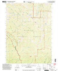
2001 Map of Yellow Dog Peak
USGS Topo · Published 2004About this map
The Marble Mountain Wilderness dominates this corner of the Klamath National Forest, defined by a network of high ridges and deep river canyons at the start of the 21st century. High-country landmarks like Yellow Dog Peak and Bear Wallow Peak overlook a landscape where the Salmon River and its numerous forks, including the Scott River, have carved through the Marble Mountains. Remote outposts and historic stopping points such as Abbott Ranch, Wilson Cabin, and The Cedars provide rare evidence of human habitation in this protected backcountry. Long-distance hikers are served by the Pacific Crest National Scenic Trail, which winds through the north, while the Ranger Trail and various gulches like Shotgun Gulch and Deadman Gulch speak to the area's legacy of exploration and forest management. The presence of Shelly Lake and Bug Lake highlights the glacial character of these high-elevation basins.
Find a feature on this map
52 named features on this map. Tap any name to fly to it.
Don’t see what you’re looking for? This feature index may not catch every label — zoom into the map to look around manually.
Map Details
Editions of this 2001 Yellow Dog Peak Map
2 editions found
Other maps of this area

1886 · Shasta
USGS Topo · 1:250,000

1894 · Shasta
USGS Topo · 1:250,000

1914 · Seiad
USGS Topo · 1:125,000

1922 · Seiad
USGS Topo · 1:125,000

1923 · Sawyers Bar
USGS Topo · 1:125,000

1931 · Etna
USGS Topo · 1:96,000

1932 · Yreka
USGS Topo · 1:96,000

1934 · Etna
USGS Topo · 1:125,000

1939 · Yreka
USGS Topo · 1:125,000

1948 · Weed
USGS Topo · 1:250,000