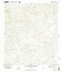
1971 Map of Yellow Hill
USGS Topo · Published 1973About this map
Lefthand Shutup and the high points of the Blue Range define this high-desert landscape in Brewster County. Recorded in the early 1970s, the terrain is shaped by the winding course of Terlingua Creek and the deep seasonal drainage of Saltgrass Draw. The map reveals a land utilized primarily for its natural topography rather than permanent settlement, with prominent landmarks such as Pinks Peak and the central Yellow Hill serving as essential navigational points. Movement through the area is restricted to a sparse network of Jeep Trails that skirt the edges of Black Ridge. The presence of a secluded Spring indicates the critical importance of water sources in this arid stretch of West Texas, where the lack of towns or commercial centers underscores the region's historical isolation and reliance on traditional ranching or surveying pathways.
Find a feature on this map
9 named features on this map. Tap any name to fly to it.
Don’t see what you’re looking for? This feature index may not catch every label — zoom into the map to look around manually.
Map Details
Editions of this 1971 Yellow Hill Map
2 editions found
Other maps of this area

1903 · Terlingua
USGS Topo · 1:125,000

1904 · Terlingua
USGS Topo · 1:125,000

1917 · Agua Fria
USGS Topo · 1:62,500

1917 · Tascotal Mesa
USGS Topo · 1:62,500

1931 · Lajitas
USGS Topo · 1:62,500

1937 · Agua Fria
USGS Topo · 1:62,500

1944 · Tascotal Mesa
USGS Topo · 1:62,500

1959 · Emory Peak
USGS Topo · 1:250,000

1965 · Emory Peak
USGS Topo · 1:250,000

1971 · Yellow Hill
USGS Topo · 1:24,000