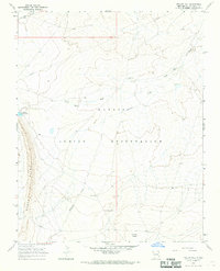
1966 Map of Yellow Hill
USGS Topo · Published 1968About this map
The Navajo Indian Reservation landscape in San Juan County is defined by a network of ephemeral watercourses and distinct geological formations as documented in the mid-1960s. The terrain is marked by significant features such as the Rock Ridge and the eponymous Yellow Hill, alongside Tocito Dome. Water management in this arid environment is evident through labels for the Big Gap Reservoir and several instances of a Flowing Well, which supported local grazing as indicated by a Corral in the northern sector. Infrastructure is sparse but purposeful, following the Red Rock Highway and a prominent industrial Pipeline that cuts across the high desert. Researchers can trace the path of Dead Mans Wash and Pajarito Creek as they drain through this territory, which also shows signs of resource exploration via a solitary Drill Hole.
Find a feature on this map
12 named features on this map. Tap any name to fly to it.
Don’t see what you’re looking for? This feature index may not catch every label — zoom into the map to look around manually.
Map Details
Editions of this 1966 Yellow Hill Map
3 editions found
Other maps of this area

1889 · Chaco
USGS Topo · 1:250,000

1892 · Chaco
USGS Topo · 1:250,000

1927 · Sulphur Spring
USGS Topo · 1:96,000

1928 · Kirtland
USGS Topo · 1:125,000

1932 · Kirtland
USGS Topo · 1:125,000

1934 · Ship Rock
USGS Topo · 1:62,500

1937 · Ship Rock
USGS Topo · 1:62,500

1953 · Sanostee
USGS Topo · 1:62,500

1954 · Shiprock
USGS Topo · 1:250,000

1958 · Shiprock
USGS Topo · 1:250,000