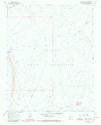
1966 Map of Yellow Hill
USGS Topo · Published 1980About this map
The Navajo Indian Reservation landscape is defined by its arid drainage networks and subtle topographic rises as documented in the mid-1960s and updated via 1979 photorevision. Two prominent hydrological systems, Dead Mans Wash and Pajarito Creek, carve through the terrain, illustrating the critical role of seasonal water flow in this high-desert environment. The presence of Big Gap Reservoir and multiple instances of Flowing Well indicate managed water resources essential for the area's pastoral and ranching activities, further evidenced by a named Corral near the northern boundary.
Find a feature on this map
15 named features on this map. Tap any name to fly to it.
Don’t see what you’re looking for? This feature index may not catch every label — zoom into the map to look around manually.
Map Details
Editions of this 1966 Yellow Hill Map
3 editions found
Other maps of this area

1889 · Chaco
USGS Topo · 1:250,000

1892 · Chaco
USGS Topo · 1:250,000

1927 · Sulphur Spring
USGS Topo · 1:96,000

1928 · Kirtland
USGS Topo · 1:125,000

1932 · Kirtland
USGS Topo · 1:125,000

1934 · Ship Rock
USGS Topo · 1:62,500

1937 · Ship Rock
USGS Topo · 1:62,500

1953 · Sanostee
USGS Topo · 1:62,500

1954 · Shiprock
USGS Topo · 1:250,000

1958 · Shiprock
USGS Topo · 1:250,000