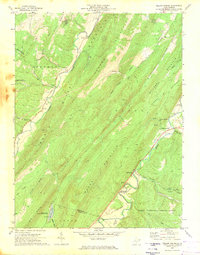
1970 Map of Yellow Spring
USGS Topo · Published 1974About this map
Cooper Mountain and Capon Mountain dominate this landscape, creating a series of parallel valleys where the North River and Cacapon River flow. In the eastern valley, the settlement of Yellow Spring sits near Mc Kees Rocks and the Yellow Spring Gap. Evidence of former transportation infrastructure is visible in the Old Railroad Grade which parallels the Cacapon River through Intermont. Local genealogy is well-documented through several rural landmarks, including Hebron Ch, Green Mount Cem, and St James Cem. To the west, the Short Mountain Public Hunting Area and Warden Lake Public Fishing Area mark significant public lands near the Hampshire Co Hardy Co line, while the George Washington National Forest covers the southeastern corner.
Find a feature on this map
43 named features on this map. Tap any name to fly to it.
Don’t see what you’re looking for? This feature index may not catch every label — zoom into the map to look around manually.
Map Details
Editions of this 1970 Yellow Spring Map
This is the sole edition of this map. No revisions or reprints were ever made.
Other maps of this area

1891 · Romney
USGS Topo · 1:125,000

1894 · Winchester
USGS Topo · 1:125,000

1916 · Capon Bridge
USGS Topo · 1:62,500

1921 · Hanging Rock
USGS Topo · 1:48,000

1922 · Wardensville
USGS Topo · 1:62,500

1923 · Middletown
USGS Topo · 1:62,500

1923 · Capon Bridge
USGS Topo · 1:62,500

1923 · Hanging Rock
USGS Topo · 1:62,500

1924 · Wardensville
USGS Topo · 1:62,500

1937 · Capon Bridge
USGS Topo · 1:48,000