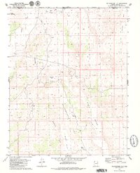
1979 Map of Yellowhorse Flat
USGS Topo · Published 1979About this map
East Mesa and West Mesa define this high desert plateau along the border of Washington and Mohave counties, where the Arizona-Utah state line meets the rugged drainage of Fort Pearce Wash. This landscape is marked by a network of seasonal watercourses like Dutchman Draw and Yellowhorse Draw, leading to scattered water sources essential for life in this arid environment, such as Water Tank and Blake Pond.
Find a feature on this map
18 named features on this map. Tap any name to fly to it.
Don’t see what you’re looking for? This feature index may not catch every label — zoom into the map to look around manually.
Map Details
Editions of this 1979 Yellowhorse Flat Map
2 editions found
Other maps of this area

1885 · St. George
USGS Topo · 1:250,000

1886 · Mt. Trumbull
USGS Topo · 1:250,000

1891 · St. George
USGS Topo · 1:250,000

1892 · Mt. Trumbull
USGS Topo · 1:250,000

1953 · Cedar City
USGS Topo · 1:250,000

1953 · Grand Canyon
USGS Topo · 1:250,000

1954 · Hurricane Cliffs 2 NW
USGS Topo · 1:24,000

1954 · Hurricane Cliffs 2 NE
USGS Topo · 1:24,000

1954 · La Verkin 3 SE
USGS Topo · 1:24,000

1954 · La Verkin 3 SW
USGS Topo · 1:24,000