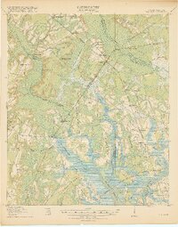
1918 Map of Yemassee
USGS Topo · Published 1918About this map
The Atlantic Coast Line RR and Charleston and Western Carolina RR converge at Yemassee, creating a critical rail junction in the Lowcountry during the early twentieth century. This survey, conducted in cooperation with the War Department, details a landscape defined by expansive tidal waters and river networks, including the Coosawhatchie River and Pocotaligo River. The mapping shows a significant network of secondary infrastructure, such as the Logging RR branching west from Gilmania and the Possum Corner Bridge spanning the swampy transition between Hampton and Jasper counties. Settlement patterns reflect the era's rural economy, with established community centers like McPhersonville, Pocotaligo, and Sheldon interspersed with smaller sidings and family-named points. Moving toward the coast, the map transitions into complex island and neck topography, identifying Halls Island, Scotts Neck, and Port Royal Island amidst the serpentine reaches of Whale Branch and the Broad River.
Find a feature on this map
71 named features on this map. Tap any name to fly to it.
Don’t see what you’re looking for? This feature index may not catch every label — zoom into the map to look around manually.
Map Details
Editions of this 1918 Yemassee Map
4 editions found
Other maps of this area

1918 · Walterboro
USGS Topo · 1:62,500

1918 · Green Pond
USGS Topo · 1:62,500

1918 · Varnville
USGS Topo · 1:62,500

1918 · Yemassee
USGS Topo · 1:62,500

1919 · Pineland
USGS Topo · 1:62,500

1919 · Cummings
USGS Topo · 1:62,500

1920 · Hardeeville
USGS Topo · 1:62,500

1920 · Okatie
USGS Topo · 1:62,500

1942 · Okatie
USGS Topo · 1:62,500

1943 · Pineland
USGS Topo · 1:62,500