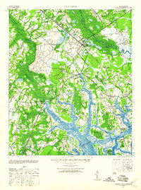
1943 Map of Yemassee
USGS Topo · Published 1960About this map
Yemassee serves as the focal point of this Lowcountry survey, where the convergence of the Atlantic Coast Line and Charleston and Western Carolina railroads established a vital transportation hub for the region during the early 1940s. The landscape is defined by the intricate waterway systems of the Coosawhatchie River, Salkehatchie River, and Broad River, which wind through extensive salt marsh towards Port Royal Island.
Find a feature on this map
59 named features on this map. Tap any name to fly to it.
Don’t see what you’re looking for? This feature index may not catch every label — zoom into the map to look around manually.
Map Details
Editions of this 1943 Yemassee Map
3 editions found

Other maps of this area

1918 · Walterboro
USGS Topo · 1:62,500

1918 · Green Pond
USGS Topo · 1:62,500

1918 · Varnville
USGS Topo · 1:62,500

1918 · Yemassee
USGS Topo · 1:62,500

1919 · Pineland
USGS Topo · 1:62,500

1919 · Cummings
USGS Topo · 1:62,500

1920 · Hardeeville
USGS Topo · 1:62,500

1920 · Okatie
USGS Topo · 1:62,500

1942 · Okatie
USGS Topo · 1:62,500

1943 · Pineland
USGS Topo · 1:62,500