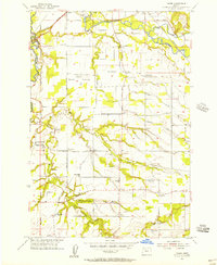
1955 Map of Yoder
USGS Topo · Published 1957About this map
The Pudding River and Molalla River basins define the agricultural and residential landscape of central Clackamas County during the mid-1950s. This area is a dense network of small communities and rural landmarks, from Barlow and Canby in the north to the eponymous Yoder in the south. The prevalence of family and community spaces, such as Marks Memorial Park and various religious sites like Smyrna Ch and Rock Creek Ch, suggests a well-established social fabric. For genealogists, the map is particularly valuable for its identified burial grounds, including the Norwegian Cem and Bear Creek Cem. The local economy of the era is evidenced by features like the Gravel Pit near the river and the Southern Pacific railroad lines that facilitated transport across the region. Smaller named areas like Gribble Prairie and Whiskey Hill provide specific geographic context for local history research.
Find a feature on this map
38 named features on this map. Tap any name to fly to it.
Don’t see what you’re looking for? This feature index may not catch every label — zoom into the map to look around manually.
Map Details
Editions of this 1955 Yoder Map
3 editions found
Other maps of this area

1914 · Oregon City
USGS Topo · 1:62,500

1916 · Tualatin
USGS Topo · 1:62,500

1923 · Mount Angel
USGS Topo · 1:62,500

1939 · Molalla
USGS Topo · 1:62,500

1939 · Oregon City
USGS Topo · 1:62,500

1939 · Tualatin
USGS Topo · 1:62,500

1940 · Tualatin
USGS Topo · 1:62,500

1940 · Molalla
USGS Topo · 1:62,500

1940 · Mount Angel
USGS Topo · 1:62,500

1941 · Oregon City
USGS Topo · 1:62,500